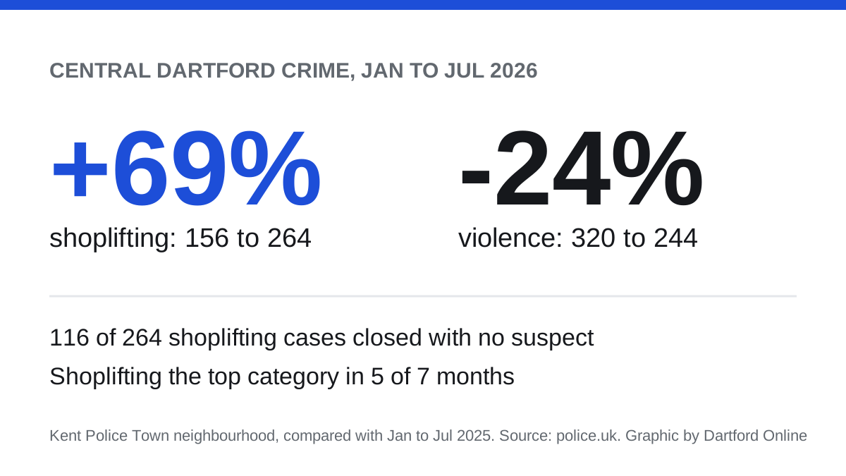

Shoplifting in central Dartford rose 69% in the first seven months of 2026 while violent crime fell 24%. Police figures, month by month, and the outcomes.
Shoplifting has overtaken violence as the most common crime recorded in central Dartford. Police logged 264 shoplifting offences in the town centre between January and July 2026. That is up 69 per cent on the 156 recorded in the same months of 2025.
Violent and sexual offences moved the other way. They fell 24 per cent, from 320 to 244.
The figures come from the street-level crime data that police forces publish on police.uk. We counted every crime mapped inside the boundary of Kent Police’s Town neighbourhood, the policing area that covers central Dartford (Kent Police: Town neighbourhood). The area is about 2.4km from north to south and just over 1km across, so it takes in more than the High Street itself.
Five of the last seven months
In every month from January to July 2025, violence was the largest category in the Town neighbourhood. In 2026, shoplifting came top in five of the seven months: January, March, April, May and July.
| Offence type | Jan to Jul 2025 | Jan to Jul 2026 | Change |
|---|---|---|---|
| Shoplifting | 156 | 264 | up 69% |
| Violence and sexual offences | 320 | 244 | down 24% |
| Anti-social behaviour | 226 | 209 | down 8% |
| Criminal damage and arson | 88 | 67 | down 24% |
| Possession of weapons | 5 | 12 | up from a low base |
| All reports, including anti-social behaviour | 1,084 | 1,072 | down 1% |
The overall total barely moved. What changed is the mix.
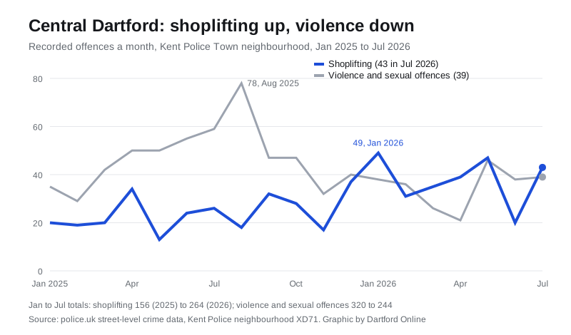
July 2026 is the latest month published. The neighbourhood recorded 178 reports that month:
- 43 for shoplifting, the highest category
- 41 for anti-social behaviour
- 39 for violence and sexual offences
A year earlier, in July 2025, the same area recorded 59 violent offences and 26 shoplifting offences.
The month-by-month counts come from the police.uk data API.
It is not only the town centre
The same comparison across the whole of Dartford borough shows the same direction, less sharply:
- shoplifting rose 30 per cent, from 1,336 to 1,737
- violence and sexual offences fell 14 per cent, from 2,735 to 2,348
We counted the borough figures inside the Office for National Statistics boundary for Dartford (ONS Open Geography Portal).
Where it was mapped
Police.uk does not give exact addresses. It places each crime at the nearest of a set of anonymous map points, labelled by type or street name. For shoplifting in the Town neighbourhood between January and July 2026, the most used points were:
- “Shopping Area”: 86 offences
- William Mundy Way: 72
- “Parking Area”: 41
- Market Place: 16
A label like “Shopping Area” is a map point near the crime, not the name of a shop. We have not named any business, because the data does not say which one was hit.
How few found a suspect
Each crime on police.uk carries its latest outcome. Of the 264 shoplifting offences recorded from January to July 2026:
- 116 (44 per cent) were closed with no suspect identified
- 67 were awaiting a court outcome
- 23 were still under investigation
- 19 were closed because police were unable to prosecute a suspect
Outcomes are updated as cases progress, so these numbers will change for the most recent months.
What the figures cannot tell you
Recorded crime depends on what gets reported, and on where police are looking. More shop staff reporting thefts, or more officers patrolling the shopping streets, would both push the shoplifting count up without any change in how much theft actually happens.
The data also stops at the end of July. It does not include the serious assault on Dartford High Street on 11 September, for which two men have been charged.
What it means for you
- To see your own street, enter a postcode on police.uk.
- Shop owners and staff can report thefts online to Kent Police, or call 101. Call 999 if a crime is happening now.
- The Town neighbourhood team can be emailed at csu.dartford@kent.police.uk, the address police.uk data lists for the area.
Sources
- police.uk data API: street-level crimes (monthly counts by category for January 2025 to July 2026, counted inside the Kent Police Town neighbourhood boundary, XD71, and the Dartford local authority boundary; outcomes and map-point labels; retrieved 17 September 2026)
- Kent Police: Town, your area (area and contact details)
- ONS Open Geography Portal: Local Authority Districts, December 2024 (Dartford boundary, E07000107)
Have your say